MyHimalayasimpressions from |
|
|||||||
Steep and narrow trails need to be taken to get from Sangda La to the Sangda
village.
The village and its field hang on the southern wall of the Sangda valley.
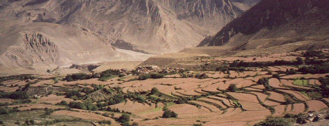
An oasis in a desert, Sangda village.
Last view to Sangda before reaching the ridge which runs parallel to the Kali
Gandaki river.
We follow the Kali Gandaki for the rest of the day. The trees and fields of
Tangbe village are the only sign of life.
Tangbe from the pass just before Phalla village.The white riverbed is full of
water during monsoon, but Mustang is usually safe from heavy rain because all
the clouds burn off while drifting north.
Looking from Phalla pass towards south where the Nilgiri north face peaks out of
the clouds.
Pink terraces of blooming buckwheat fields surround the Phalla. Despite its
closeness to Jomosom, it does not seem to be visited by many tourists.
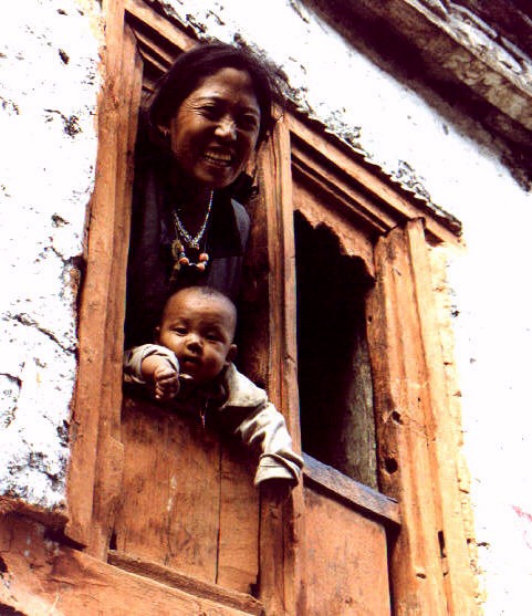
Mother and her baby looking out of the characteristic orange window in Phalla.
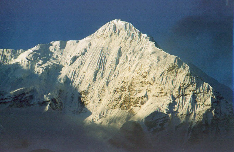
Sunrise on Nilgiri, illuminating the steep ice fall.
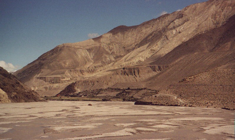
The broad riverbed narrows near Kagbeni whose red monastery can be seen from far
away.
View from Kagbeni to Nilgiri.
The way along the river from Kagbeni to Jomosom is usually (over)crowded, but in
the middle of September only few tourists visit the area.
Saying good-bye. Without those people our trek would have been impossible!
Dolpo to Mustang: Sangda - Jomosom
Sangda to Jomosom
before Sangda – after Sangda (Day 17)
I wake up shortly before the alarm rings at 500. It is foggy and probably will not clear anytime soon, so I crawl back into my sleeping bag instead of walking uphill for some exciting views. To hear the first rattling of pots in the kitchen tent is cozy.
The air is wet from fog, mist makes walking through juniper trees even more pleasant. After the cool and dry mountain air of the last two weeks I almost feel I can touch the the heavy scents. The fog softens all noises, the silence leads to a strangely solemn atmosphere that is only broken by the singing of a few birds. Half an hour later the morning sun and a strong wind improve visibility. It seems that we will not get another day like yesterday.
The path to Sangda is on the other side to the valley but the direct trail from the pass is much too difficult for non-locals. Khami found a bridge yesterday so it will be no problem. Before we reach the bottom of the glen where we will cross the river we have to descend into a valley just above. The washed out yellow sandstone resembles huge organ-pipes. Not many people take this path, it is not maintained and we walk over muddy rockslides most of the time.
The trail drops quickly and leads to a vertical wall where it looks more like a rock carving than a path. At least 100 metres of sheer rockface towers above us, and it’s another steep 30 metres to the ground - I am not unhappy to have left this part of the way behind me. A solid bridge was built here a year ago but will soon be useless, because the trails leading to it will be destroyed.
After 30 minutes of climbing we reach the trail we saw yesterday afternoon, a thin line in the barren rock. But the path is broad and not as difficult as it looked. The mist has completely dispersed, but clouds hide the mountains higher up. Part of the mountain we came down yesterday is visible; from here it looks as if one has to rockclimb down since it is steep and no trail exists. I cannot believe we came down the mountain’s flank. Our campsite is one of the very few flat spots on the steep mountain.
On the opposite side are a few small terraces, quite a distance away from the village. People have to use every place for agriculture because there is simply not enough land. The valley is desolate and narrow, we do not pass a single field before reaching the town. Husbandry is much more difficult here than in Upper Dolpo where there is good grass on the alpine pastures. We pass a flock of goats but there does not seem enough food to have several big flocks. The valley is picturesque but not a place made for human habitation. Its beauty comes the barrenness which is nicely contrasted by small spots of vegetation.
The trail goes down a huge washout where a mixtures of big rocks and mud have been eroded by water. Walking beneath a 20 metre high wall of this loosely looking material is impressive but not very comfortable. I just do not want to be here in July or early August, though it would be interesting to see how the rain forms the landscape. After walking down a lovely forest which grows on sand dunes we cross the small Rikha Samba and another side valley. Finally we reach the yellow fields which we have seen from so far away.
The village was founded by a family that had to leave Mustang because a member committed some crime. It must have been a heinous crime, because although punishments in those times were harsh (a thief had his hand cut off when repeating the offence) it was certainly not common to expel a whole family. This explains the location of the settlement, I was wondering why people live in such a narrow and barren gorge. Their reputation does not seem to be good even today, allegedly they do not have a lama and simply throw the corpse of a deceased in the river.
Dilapidated houses and washed away terraces can be made out on opposite valley wall. This was the original settlement which had to be given up because the creek dried up. Moving all fields and houses to the other side and creating plateau might have taken around 2 years, during which the villagers did not have time for many other things. This must have been a very difficult time economically, but since there is much more space for fields over here people should be doing better. The wheat is almost ready for harvesting, the season is a few weeks ahead of Tarap.
The people consider themselves to be Gurung, an ethnic group from north of Pokhara. But they are clearly of Tibetan origin and just call themselves Gurung to be somehow included in the Hindu hierarchy. The same happens in Mustang where the higher class and aristocrats call themselves ‘Bista’ even though they have nothing in common with them except for a higher status.
An older woman shows us to a house where the kitchen crew can cook and buy some fuel and food. As usually the outskirts are used as rubbish heap and for once we are about to cross a chorten on the right side when the old woman says ‘Kora kora’ and we walk through the trash on the chorten’s left side. We stop in the courtyard of the first house and stay there for lunch. A young woman digs potatoes out of her garden, I have probably never eaten such fresh potato soup and chips.
I meet our hostess again on the roof. She is very pretty, her features are not the ones of a Dolpo-pa. Khami is suddenly not hungry anymore and spends the time on the balcony; our teasing does not seem totally unjustified. I do not want to make stupid simplifications, but I think the prettiest women come from Khumbu and Ladakh, the girls from Upper Dolpo are not as attractive. This is not important at all, wherever you go in the Himalayas, particularly in the more remote areas, hospitality and friendliness are the same, and this is what counts. One of the pleasures of travelling in the Himalayas is that people are quite self-assured and tourists and locals are on the same level, you are neither seen as superior or inferior.
Exploring the village is not easy because the dozen houses are built so closely to each other that it is almost impossible not to disturb somebody’s privacy. From far away we have seen a herd of cattle and people above the village. It looked like a cattle-market, but it is a caravan in the last stages of preparation for departure. The yaks’ legs are tied together to make it easier to load them. Two hours later they will leave for Sangda La, how they will cross it is a mystery to me after all the problems we had yesterday.
Supposedly the water in the village is not clean, and because it will make tomorrow’s walk shorter we decide to camp outside the village. A strenuous climb begins after the pass the empty school, but after two weeks of daily training I get to the ridge fast. I am in very good shape now, as usually it took me two days to get used to walking but since then I have become faster and faster.
The view is breathtaking, the fields below are an oasis in a mountain desert, not only due to their colour but also because they are the only flat area in the whole valley. The peaks and glaciers are hidden in clouds, but the view eastwards is amazing: a narrow gorge leads to a landscape dominated by hundreds of canyons that characterise Upper Mustang. I wonder if it is the actual scenery or my memories that make me stare in awe, probably both. After spending an hour on the top we continue towards the yellow dots in the next valley.
Our tents have already been put up in a slope which is dominated by a huge black wall with snow on its ridge. The only source of water is a spring far below the tents. Luckily some locals have built a few small terraces, otherwise it would be impossible to camp here. Finding camp places in the Himalayas can be difficult! I know how strange this sounds, but clean water next to flat areas are not so common, and you usually want to set up the camp in the late afternoon which reduces the number of suitable spots even further. At least here you do not have to fight over camping grounds like in the Annapurna or Khumbu area during the high season.
Dozens of blue sheep are grazing higher up. For a quick second I am tempted to hike up there to see how close I get to them, but the sun is already setting behind the mountains and I have to skip the idea. Soon afterwards it becomes foggy, which makes tea and biscuits in the tent an even better alternative.
Sangda – Phalla (Day 18)
Once again I have set the alarm clock to 500, once again it is too foggy to justify a pre-breakfast run uphill. After the first glimpse of Mustang yesterday afternoon I cannot wait to see the canyons from closer. The Sangda gorge branches off at a right angle from the Kali Gandaki valley. We will get there in an hour and then follow the broad riverbed for the rest of the day. The views from the ridge should be spectacular.
I climb a nearby hill in hope for better views, and with good weather this really would be a perfect viewpoint: the Sangda valley with the snow peaks, the barren scenery of Mustang and the steep face of Nilgiri and Tilicho in the south. But it is too early, the sun could not burn off the clouds yet and the huge peaks of the Annapurna massif are only visible for a few moments, yet over Mustang there is bright sunshine.
Everybody is far ahead, even the liaison officer passed me. I hurry up and catch up at the next pass from where the view is even more breathtaking. The weather has improved, the good light increases the spectacular views even more. Mustang lies to our feet, the trail from Samar to Shyangboche is chiselled into a hill on the far left, and I think I can even make out the small path leading to Rangchung Chorten, although this be imagination. It is incredible how far we see from here: I recognise the plateau near Tsarang but the town itself is hidden behind some hills. Below us are the fields of Chuksang and Tangbe. The oases farther south are Kagbeni, Jarkhot and Muktinath. It is a pity that Thorung Peak and the hanging glaciers which tower above the valley are covered in a thin band of clouds that span down all the way to the south, hiding most summits. On a clear day this must be one of the finest views I can imagine. It is definitely on my ‘Himalayan top ten list‘ under the category ‘most interesting views’.
Actually this was planned to be a short day and it is possible to reach the camp at noon. This would have been most convenient for the kitchen crew but our long breaks and my little sidetrips have taken too much time already, and there might be even more excursions before we reach Phallyak. So we stop at the next river for lunch, the tiny stream is the only source of water between Sangda Phallyak. It runs dry a hundred meters further down, a few ruins indicate the remains of a village which was probably abandoned because of lack of water. It is another reminder of how difficult and hard life is in the Himalayas. The average tourist marvels at the majestic scenery, which is so stunning that one never thinks about the dangers and difficultiees of living in the highest mountains on earth.
We have reached the last pass of our trek. Down in a wide side valley lies the village where we will stay for the night. The north face of Nilgiri is free of clouds and the view towards north better than during the whole morning. To the left is a small hill which promises even better views, a higher hill is a little further away and after reaching it it is only a few more minutes to the very top. The tough half-hour climb is not easy, strong gales make it even more difficult, but it is absolutely worth it. The world’s deepest valley lies beneath us. It is one of the few north-south corridors between the Indian subcontinent and the Tibetan highplateau, an incredibly strong wind is an indication of this. We stand on a ridge high above anything else, and enjoy one of the most stunning views on the trek. Barren landscapes seem boring at first, but it simply takes awhile to discover the subtle differences in the scenery, and then it is like a puzzle where more and more pieces are being added with every minute you watch.
The bird’s-eye view of Mustang is spectacular, just across us lie the fields Tangbe, and red canyons rise behind the yellow patches of wheat. A few miles upstream the broad riverbed disappears all of sudden where the Kali Gandaki seems to spring out of a red rockface. It flows through a tunnel there, coming from narrow gorges of Upper Mustang. This also marks a drastic change in the scenery, chaos of red, yellow and grey canyons stretch to the whole north. The views in the other direction are also fantastic, only a few small white clouds drift in front of Nilgiri’s glacier which is more impressive than from
Tomorrow will be another day of trekking and we will have extra days in Jomosom, but somehow this seems the right moment to think about the last three weeks. It has been an exciting trek, for some reason attempted by less than ten groups a year. I have expected at least some problems, either logistically or healthwise – it was Thomas’ first trek and I have never trekked for so long and crossed 6 passes over 5’000 metres. But we were in good shape and it was organised perfectly, so we did not have to care about anything else than our own walking. There were two moments – the long walk in the valley after Charka to Sangda La and the miserable walk after the Sangda La – when I asked myself if the effort and money to walk from Do to Jomosom are really worth it. But after a little sunshine and the breathtaking views days all doubts (which were only slight anyway) are gone. It is a fantastic route that requires a good trekking agency, endurance, curiosity, rain gear and a little bit of extra money. But it is rewarding!
I hope that nobody has been waiting for us on the windy pass before Phalyak for the last hour. Phalla looks like a typical Tibetan village from the pass. The whitewashed houses with firewood and prayerflags on the flat roof look like most villages in the Western Himalayas. Pink blooming buckwheat fields which are separated by green stripes of young corn surround it. The large terraces follow the gentle slope down towards the broad river. I think it is their form which gave the town its name, as far as I know Phalla means shingle. Three different coloured chortens above the village with Nilgiri in the background makes it even more picturesque.
After reaching the fields it takes only a few minutes to the village’s entry. A big landslide or torrent has torn down part of the valley, the elevation serves as the town’s outer wall. The main entrance cannot be missed, it resembles the entering of a fort. We camp on a place for thrashing at the outer wall where the curious villagers have sat down already. Despite its closeness to Jomosom – the most visited trekking area in Nepal – only few tourists visit Phalla. I wonder why, as far as I know it is not in a restricted area. At least those heading for Mustang could take the route from here to the pass for the fantastic ‘preview’ of their trek, than walk down to the checkpoint in Kagbeni. It is a much nicer way and less crowded than the standard route. I do not spot a single guesthouse or shop, which I am very happy about since we will see those ugly signs early enough tomorrow.
Phalla – Jomosom (Day 19)
Mornings like today are trekkers’ dreams: Nilgiri glows in the morning sun and forms an orange triangular in a blue sky. The light shines on the icefalls and the channels of ice, illuminating the fine vertical lines in the white snow. Just a few minutes later the ‘magic of the moment’ is gone, the light turns from orange to yellow, gets brighter and makes more and more of the north face visible while blurring out the subtle contrasts. Clouds from the south are covering Tilicho already, so once again we cannot see the whole range.
The porters spent the night in the village and show up after breakfast. This is our last day with them, after a short walk to Jomosom they will drop our bags and continue to Beri or Baglung where they will take the bus to Kathmandu. Since we will make a short detour over Kagbeni, it is time to say good-bye. I hope they found the last three weeks also as pleasant as we did. I don’t particularly like the ‘tip-ceremony’, it is always a bit awkward for everybody. I hope they liked Travelling without a good crew would be very, very difficult and could easily spoil the holidays. Just the thought of a bad meal after five hours of walking makes me shiver. You totally depend on your crew, and so far I have never been disappointed.
We walk down towards the Kali Gandaki on different sides of the gorge and see them slowly disappear. The old way to Kagbeni is on this side of the river, but a new long bridge crosses the wide riverbed near Eklabhatti. The red monastery of Kagbeni stands out from far away, it is situated above the green fields near the river. It is a familiar sight and looks as pleasant as last year from far away, but the town has changed considerably since then – for the worse. At least a dozen new guesthouses have opened up, shops and restaurants dominate the townscape. Even the old part of town which was so picturesque shows signs of tourists influence - literally. The old fort is in ruins, some houses share the same fate but the narrow alleys and courtyards let you guess what it must have been like dozens of years ago.
I wonder if Mustang’s and Dolpo’s villages are destined to end like Kagbeni with its ugly tourist infrastructure. Much less tourists go up to the remote regions, but even there tourism is an additional source of income. I do not have a right to complain, because I am a foreigner and will never really know how much easier a villager’s life can be with a little extra money.
The monastery is well cared for and seems affluent, has nice paintings and statues. The assembly hall is still used, but most monks are away right now. The new building whose construction was started last year and is financed by entrance fees or donations is not quite finished, but since the cracks in the old monastery have not become wider in the last year there is no time to hurry.
We soon start our walk back, I am rather shocked by the huge changes that took place in just one single year. Eklabhatti consists of just three guesthouses near the river, and because they don’t dominate the face of a village, it is not as bothering as Kagbeni. The woman who runs it speaks Tibetan and I enjoy the standard 5-minute conversation until I run out of words. I notice once more how our crew seems to getting along with the locals much better than the guides of other groups. Padam stayed behind while we walked to Kagbeni and prepared lunch. Since will probably be the last time I enjoy the triple portion dal baht even more.
The way to Jomosom is very familiar, and I do not like it very much. Punctually at 1100 a strong wind blows from the south, making our walking not more pleasant. The valley is probably interesting for somebody interested in geology, but the broad riverbed and barren hills are not captivating after having seen it three times. The tin roofs of Jomosom blink in the sun one hour later, but it takes at least half an hour to get there and then another half hour to the airport. Modern civilisation has us back... and though I have to admit that I have no distaste for Western luxuries Jomosom represents the worst of both worlds: it is clearly a tourist centre but does not offer real comfort.
The tents are already put up in the backyard of a guesthouse. I spend the rest of the afternoon washing clothes and relaxing. This will be the last dinner by Padam, after eating half the chocolate pie our stomachs are about to explode.
I hoped for a more exciting day, but my mind probably finished the trek shortly before reaching Phalla yesterday. The view from the pass was unforgettable and dramaturgically perfect.
This Dolpo trek was superb. Even though the weather was not great all the time, it could have been much worse. We had great views and enjoyed the stark contrasts of the scenery – from lush terraces in Dunai, through thick forests, the wheat fields in Ringmo with the fantastic lake Phoksumdo, the barren hills and high passes of Inner Dolpo, the wide fertile valley of Tarap and the desolate gorges of Sangda and Upper Mustang. I will particularly remember the people, their friendliness and hospitality. Our crew made the trekking very easy and enjoyable.
But with every tourist the chances grow that things will change for the worse. I hope that my presence has not had negative side effects and that my visit did not change the people.
|
Summary Part 6:
After the difficult trail over Sangda La we enjoy the steep walk through small juniper forests. After two weeks in dry air the smell of trees and grass is almost overwhelming. The yellow terraces of Sangda stand out from far away, the dozen buildings are closely built to each other. We get another great view of the village from a pass high above it. The red and yellow canyons of Mustang dominate the scenery in the east - a completely different landscape. A high ridge runs parallel to the Kali Gandaki valley and we get even better views of Mustang. Thorung Peak is hidden in clouds, but the villages Muktinath and Jarkhot appear as oases just opposite the broad white river bed. The steep north face of Nilgiri is the centre of the Annapurna massif to the south. We spend the night in Phalla, a nice Thakali village lying between blooming pink buckwheat fields. After a short detour over Kagbeni we reach Jomosom, the end of our trek. |