MyHimalayasimpressions from |
|
|||||||
First view of the village and lake, a great change after three days in
the dense forests.
We set up our camp near the shore, a few minutes away from the village. The play
of colours is stunning, especially just after sunrise and shortly before
dusk.
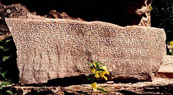
Carved stone on one of the mani walls just before the village.
The large chorten in the village has nice paintings on all four sides and nine
fine mandalas on the ceiling.
more paintings in the chorten
The Bon monastery stands on a cliff at the other end of the lake. It is only a
short walk in the juniper forest along the shore.
A group of several chortens announces the monastery.
Phoksumdo lake is the source of the Suli Gad.
View from the lake towards Ringmo.
Only few men are in the village during summer, mothers and their children are on
their own.
Tall mountains surround the village. Norbu Kang and the Kanjiroba massif are
above 6'000 metres, adding to the fantastic play of colours.
The water falls down the ridge which separates Ringmo from the valley in the
south.
The trail to Shey starts just above the shore and then climbs high above the
lake which offers fantastic views.
After a few minutes in the shade of a forest in a glacial valley, we slowly
climb the ridge in the hot morning sun. The ochre houses and lush fields of
Ringmo are getting smaller and smaller.
Trekkers' dreams!
A yak caravan is coming from Shey, the first people we meet after leaving Ringmo
two days earlier.
The last mountain range that separates us from Shey. Upper Dolpo starts after
the ridge, the landscape will be dominated by barren hills and the Tibean high
plateau.
Dolpo to Mustang: Ringmo - Shey
Ringmo to Shey
Sumdwa – Ringmo (Day 4)
The clouds and fog in the morning come as no surprise, I woke up twice at night and heard the sound of drizzle on the tent. I put on my raingear and although the rain stops as soon as I’m wearing it, a cold wind does not make me regret it. Bits of blue sky shimmer through the clouds only a few minutes later; weather changes happen incredibly fast here.
Soon after the checkpoint a steep and long climb starts to the ridge which separates the lake from the valley. Another valley branches off on the right-hand side, on the way to Baga La and Do one passes the yellow and green fields of Pisang. Slowly they disappear in mist and heavy fog from the valley reduces visibility to 200 m. The trail becomes flat for a few minutes, a welcome rest before the real ascent begins! It takes another hour of fast walking to get to the top which is almost 3'800 m high. A waterfall is roaring deep, deep below us. It is one of the highest in Nepal, we wait a few minutes in hope for a good view. In vain, only the snakeformed white river breaks through the mist for a few seconds. Most of the porters we passed on the way up have caught up and even the liaison officer arrives a little later. He speaks little English but seems to be a friendly yet reserved man. Hopefully he won’t turn into a fussy bureaucrat when the time comes to make decisions.
A small hill is the last obstacle before Ringmo. I am very curious to see the village, I guess it is one of the highlights of our trek. Huge red-coloured rocks are to our left, bright green fields on gentle hills to our right. The stark yet natural contrast of such sceneries is what makes trekking so enjoyable. The clouds suddenly disperse when we reach the first chorten. Soon another chorten follows and we pass the first maniwall on its right side. This feels very strange, normally you should walk around it clockwise in the direction of the Buddhist’s wheel of life. But now we are in one of the few remaining areas where the pre-Buddhist religion Bon is still practised. Their philosophy and iconography is now very similar to Tibetan Buddhism and for amateurs like me very hard to distinguish.
According to Bon legends their religion was founded 18’000 years ago by Tönpa Shenrab. Historical facts show that it was widespread in Tibet, practiced from Guge in the west to Amnye Machen in the far east. It was only little organized, and this lack helped increase the importance of Buddhism around 900 AD. Afterwards Bon added structure and consistency to their philosophy and included some Buddhist concepts and iconography. Buddhism on the other hand adopted many Bon practices like prayer flags, protector deities and local gods and demons.
Ringmo’s biggest chorten has paintings of figures which seem to be Buddhist, yet they all appear in the Bon religion. Once the dominant religion in Tibet, it was replaced with Buddhism by Padmasambhava, a scholar from India who was also the founder of the Nyingmapa sect. Monasteries of Buddhism and Bon can both be found in Upper Dolpo, and both share the same problem: their influence is on the wane, monks and nuns are becoming rarer. Families would rather their children speak good English instead of being to able to understand old Tibetan scripts. In earlier times Dolpo was also not famous for large monasteries - there were none – but for learned and pious lamas.
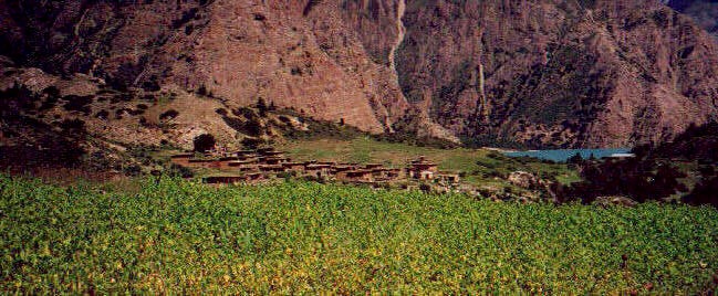
It feels great to arrive in Ringmo. The atmosphere is quite different from the villages further south, this is emphasised by the wide surroundings and the sudden improvement of the weather. Fields and flowers, dense forests and the pleasant temperatures make this seem to be much lower than 3’400 metres. After the rainforest and the narrow valley Ringmo is an even merrier place. The village is built along a small hill; all houses are quite large and share the same brown colour and architectural style. The only thing standing out is the whitewashed chortens.
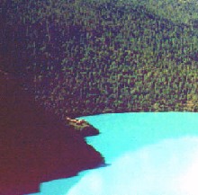
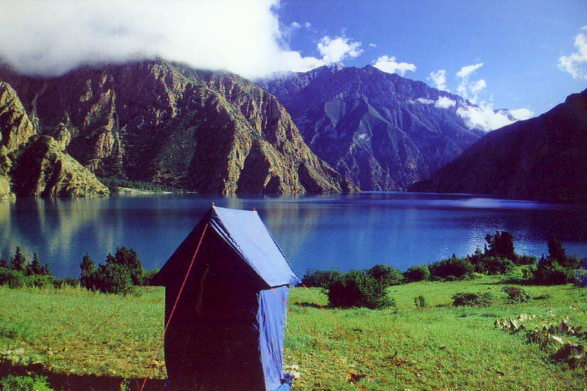
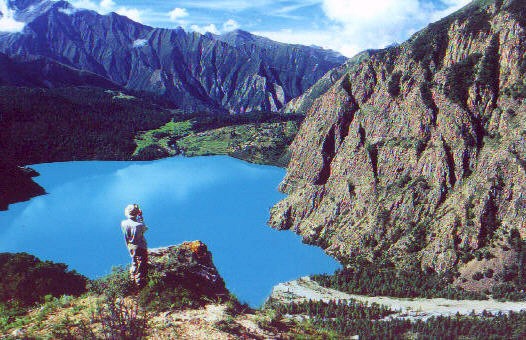
I cannot wait to see the splendid lake, after the cloudy morning I was prepared to see no lake at all. So when I reach the last hill before the camp a feeling of happiness and gratitude overcomes me when I see the green-blue lake in front of me. This is one of the few cases where the term ‘turquoise’ is the only word to describe a colour. The same fantastic colour spans from the shallow shore to the very end. Since steep rockcrags form the other shores, no vegetation fades or blurs the lake’s colour. Within a split second all the (relatively little) rain of the last two days is forgotten. We camp on the meadow near the lake’s shore, a fantastic spot.
Padam’s Western meals are very good, but we like his Nepali dishes even better so we have ordered dal baht for lunch every day, with potatoes or vegetables as a welcome side dish. I hope we did not offend him by suggesting such a simple meal, but it is hard to imagine something else that tastes so good and gives so much energy. This is our first day at ‘high altitude’ and the body should be given some rest, but anybody who spent the afternoon in the camp would be crazy.
I take the chance for one of the rare ‘head-to-toe’ baths, even though I am not very dirty yet. I will probably not be that clean again the next two weeks since the water won’t get any warmer. And trust me, it is very, very cold already.
After another fantastic lunch and a bath in the lake I am eager to do some walking and exploring.
A herd of yaks and dzos are driven to a meadow at the other side of the lake. A very narrow path runs 20 m above the waterline. After the forest the trail disappears, there seems to be a zigzag path upwards but it is very steep and leads into a precipice. I wonder if that is the way to Shey.
The views must be even better from higher up, after a very slow climb I pass three chortens and reach the top of the hill a few minutes later. The lake is an important part of the scenery, but by far not the only one. A mountain range forms the valley wall in the south, the most prominent peak is a pyramid of ice and snow, probably Norbu Kang (6005 m). The eastern wall of the Ringmo valley is formed by steep rocks, a dense forest lies just below those dark mountains. On a clearing between the steep walls and the lake are the ten buildings of the Bon monastery. Light green wheat and yellow grass grows between the forest and the Sali Gad river, which is the lake’s draining off. The actual village lies on this side of the river, the two dozen houses are situated between wheat fields. The number of colours and their composition is perfect.
This would also be a good spot to watch the life in the village if I had brought binoculars. I am 200 metres away so it is impossible to tell what people are doing exactly, but much of the work is done on the roofs and it is interesting just to sit there and watch.
We will have enough time to visit the monastery tomorrow, but since it is still a long time to dinner and the weather is so fine I take another walk, motivated more by the scenery than by the cultural relevance of the monastery. The afternoon sun gives the fields a yellow touch, it is very quiet and I will remember this stroll as an especially pleasant one. The path splits shortly after the bridge, I continue towards the lake, passing a few chortens that stand in the midst of the green fields. After ten minutes I am in a Mediterranean pine-tree forest with the unreal blue of the lake below me. The faint sound of splashing water adds to the errie atmosphere. It is almost too perfect to be true. I can see the prayerflags and the monastery on the cliff already but it takes another ten minutes till I get to the monastery complex. It consists of ten buildings, many seem abandoned and all are locked.
After resting and enjoying the views of Kanjiroba Himal, I return to the camp just in time for tea and biscuits. Two cute kids stop by and give us flowers and some plant seeds in exchange for whatever we are willing to give; we trade half a cereal bar for their flowers.
The colour of the lake changes constantly. When the sun is hidden by a fast moving cloud, the lake’s green turns into a darker, more blue-ish tone. The subtle different colours that appear at the same time are wonderful but probably impossible to capture with a camera. I have to restrain myself from taking picture after picture; the colour always seems a little better than five minutes before.
A legend describes the formation of the lake. A local demon was being chased and hunted by Padmasambhava, the Buddhist scholar from India. While fleeing she offered the villagers a large turquoise if they did not tell Padmasambhava her whereabouts. The villagers agreed and received the stone. When the Buddhist master arrived, he guessed what had happened and turned the turquoise into dung. The villagers felt betrayed and told him where the demon was hiding. She in turn took revenge by flooding the village. [Supposedly a Japanese team scanned the ground of the lake with a submarine but could not find any remains of a settlement. I don’t know if that story is true or just another funny story about the Japanese in the Himalayas.]
When the sun disappears behind the Western ridge it gets chilly within minutes. The lake is now dark blue which increases the feeling of cold temperatures, the turquoise colour of the afternoon conveyed a certain tropical feeling.
After dinner I fall asleep - tired, slightly sunburned and very happy.
Ringmo (Day 5)
Today is our first rest day. We don’t actually need to rest after only four days of walking. But it makes sense to plan one in Ringmo, because 1) it is a charming and interesting place 2) it is a good idea to stay here to get used to the altitude 3) flights to Juphal are not very reliable and an extra day to catch up can be very useful.
I enjoy sleeping in but wake up early enough to watch the first sunrays hit the lake and the mountains around it – while sitting in the warm sleeping bag and enjoying a cup of tea. The morning is wonderful, blue sky with a few white clouds, a slight breeze and a fresh smell.
It is nice not having to hurry in the morning for once. The few remaining clouds have been blown away by the time we finish breakfast and leave for a short walk to the waterfall. It can be seen from two different sides, the one we came from yesterday and from a hill on the other side of the river. After passing the village and walking through fields we reach the coniferous forest. It is very quiet in here, our steps are swallowed by thick carpet of needles. A local from Ringmo is returning from the Tibetan border with Chinese goods (his packhorse carries some bottles of Chinese beer). He took the route via Saldang and Do, the casualness with which he describes the journey on dangerous paths and with little equipment is just mind-blowing. Even more so when compared to our luxurious and (relatively) easy trekking. When you hear trekkers talk about their trips in the Himalayas it often sounds as if they walked 2000 km in two weeks on their knees in a snowstorm with 200 kg on their back and no food for days. Admittedly, there can be a difficult day occasionally, but usually it is very easy, you do not have to worry about anything, the heavy bag is carried for you and you get plenty of clean and tasty food.
After leaving the forest we find ourselves on a wide and gentle hilly alpine pasture. We hear the waterfall already but continue to climb until Khami finds the perfect spot on top of a small hill. The river falls down about 250 metres in several steps, spray forms a rainbow next to it. Just below the village are green fields, a high peak of the Kanjiroba Himal towers above it all, but clouds conceal the upper part of the mountain. Its peak and glaciers are visible just for a few seconds. The lake is a small dark blue dot which contrasts nicely with the ochre tones of the mountains and the green of the pine trees. The only great view of Ringmo missing is the one from the path to Shey, and hopefully we will get to see that tomorrow.
After a long rest at the waterfall we start walking back. Before going to lunch at the camp we visit the monastery. Again it is a very pleasant walk, again nobody is there. It is surprising because of a monastery with 10 buildings you would expect to find a least a few monks. They might be in retreat in a separate gompa, during a time of 3 years, 3 months and 3 days they are not allowed to visit the village. The remarkable site of the monastery helps me over the disappointment of not meeting anyone here. I wonder how important the monastery still is to the villagers. I hope that their culture can keep its relevance even when they are moving towards a more Western way of life.
Many tourists are looking for the ‘untouched’ place where things are as they were hundreds of years ago. When they notice that ‘modern times’ have also started in regions so far away, they complain and cannot understand why someone wants electricity, radio, medicine etc. Admittedly, many Western inventions are expensive, useless, stupid and threatening, but one should not forget that modern infrastructure has the potential to make locals’ lives easier. Therefore we have absolutely no right to complain, especially because after satisfying our curiousity for a week we will board the plane to return to our normal, luxurious lives – and normally do not pay much attention to the problems we have seen.
In the afternoon I wander around the village. I am a bit shocked how many things I have missed and how little I have noticed yesterday, my focus so far has been mainly on the fantastic scenery and not the village itself. The architecture is quite different from anything I have seen in Nepal, Tibet or Ladakh. The houses in those regions are usually two-story-high whitewashed stone buildings with a flat roof, small doors, a few small windows and a little woodwork. In Ringmo they feature a small building on the roof which makes an extra story. The windows are also small to keep out the cold and heat, but they have a nicely carved wooden frame. Doors are wider than usual and open into a stable and storeroom from where a ladder goes to the second floor. Every house has a porch before that door, carved pillars support this construction. A few of the doors have a small ledge above it on which carved manistones or pictures of deities are placed. The bare rocks which form the house’s wall are not whitewashed, or maybe the rain has washed the paint away. After each one-foot high layer of stones follows a long horizontal plank which gives the wall stability and also a nice visual structure.
Except for old men only women and children are in the village during the summer. The men are away on business, some go as far as India to do trading, others travel north to Tibet. I wonder if they are back for harvesting season or if the women do it themselves. Right now they spend most of the time on the roof or on a weaving machine in the garden. Maybe I am wrong, but women here are much more independent and self-assured than in Hindu society. The children have lots of time, they sit in front of the tent for half an hour hoping for chocolate or ask 20 times for a pen. Some idiot must have given away balloons recently, all the kids ask for them. It is difficult to sit down without being hassled by the kids.
Although this is a delightful place I am not unhappy to leave one day earlier than planned. We saw the path along the lake already and I cannot wait for the views from up there.
Ringmo – before Kang La (Day 6)
Today’s destination is only 200 m higher than Ringmo in a valley to the north, but to get there we will have to reach the end of the lake first. From there we will follow the Phoksumdo Khola upstream. The beginning is a small trail along the shore, after crossing a bridge the trail is chiselled in the rock above the lake, after half a mile follows a glacial valley, then the trail climbs very steeply high above the lake. After that point it is a gradual descent to the lake’s northern shore.
The first part of the trail is not for people afraid of heights. This would include me, but I feel fine except for a few spots where the path is only one metre wide and the lake 20 metres right below me. It looked more dangerous from far away. Still, how the dzos walked this way will remain a mystery.
Pine trees and large bushes grow in the small flat glacial valley, which looks very idyllic with its forest and white pebbles at the shore. Glacier water comes from a 6'000 m peak in a little stream. The riverbed is 50 metres wide, it is hard to imagine the mass of water that must flow down at some point of the year to turn the small stream into such wide river. The yaks we had seen in Ringmo were driven up to the pastures just below the glacier. Walking in the forest is a pleasant change, for after a few minutes in the shade a steep one-hour climb in the hot morning sun begins.
It is a steep slope covered with bushes. We zigzag up the hill, climb a ridge high above the lake. Lizards dart across the path, large mice hide behind rocks. Apart from that the world seems to stand still. No sound, no wind, no movement – only the fantastic scenery. When we get to a pile of stones and a prayerflag the highest point has been reached. I am surprised about the relative ease of the climb, considering the 400 metres which we have gained I’m not breathing or sweating very much. Getting to Ringmo two days earlier felt more strenuous, we have either acclimatised well or simply walk slower. Thomas felt sick during the night, but judging by his walking speed, seems to have recovered.
The views have been splendid since our start two hours ago. The gentle hills of Ringmo have become smaller and smaller, the lake has unfolded like a turquoise blanket and taken more and more of our view, the summit of Kang Norbu in the south appears as a completely white triangle. Now we are at the best viewpoint and enjoy the scenery while resting. It is breathtaking. Within the dark green forest lie the bright fields of Ringmo, the monastery on the ledge is already in the sun while the forest still lies in the shade.
The difficult part of the today’s route is behind us, from now on it will be either flat or downhill. While traversing a steep wall we see the lake’s other main inflow on the opposite shore to the east. A small stream runs in the middle of a broad and very flat valley, high mountain ranges rise next to it. We continue to the northern confluence through pine and silver birch forests. The yellow leaves accentuate the lake’s green colour, the pine trees’ sweet smell adds to the peaceful atmosphere. After half an hour of fast walking we reach the northern shore. It forms an exact half-round, the geometrical form looks strange in the otherwise rugged landscape. The lake near Ringmo was completely flat, the waves at this end give it quite a different atmosphere. Huge white clouds are over Ringmo, luckily they are blown away and we set out in perfect sunshine after lunch. It is hard to imagine a nicer lunch spot than here; lying in the grass under a large birch at the lake’s pebble shore.
The flat valley is several hundred meters wide and completely covered by knee-high thorny bushes. Snow-covered peaks with glaciers form the western wall, the opposite side is barren rock, reminding me of the mountains of Ladakh and Zanskar. As the valley becomes more narrow, the vegetation gets more diverse, young pine forest with yellow-greenish trees, high conifers like in Scandinavia, high bushes, flowers. Most of the wood used for construction in Dolpo comes from here. Many small streams flow in the valley, young birch trees grow at the riverbanks, the rest of the valley is covered with plants and flowers. From the left come crashing sounds but we never see what caused them, it must be either the glaciers’ movements or avalanches.
We cross the river several times, but since it does not carry much water jumping from stone to stone is easy. I expect it to be different tomorrow and I am not looking forward to it. The two Frenchmen we met in Juphal had to wade through it a few times and the trail was in very bad condition. Although it did not rain much in the last few days I do not anticipate a nice trail and rebuilt bridges.
This would be a pleasant walk but Thomas is feeling very sick which spoils it for me, too. He was walking fine until lunch and ate a little bit, but now he has stop more and more often because he feels very weak. I tell Dawa to camp at the next possible spot, and when we reach it half an hour later Thomas just lies down to rest. While the kitchen crew and I wait for the porters and the tents (a slight drizzle has started) we have big fun staging a shot-putting contest. Padam has to laugh so hard before even throwing a stone that he never gets very far and everybody starts cheering him up – with the result is that he is even less concentrated and has to laugh more than before.
We get to watch an incredible downpour just a few minutes after having put up the tents. It stops after a minute and I hope it is over, but soon it starts again is accompanied by a strong gales. We are in the middle of a big storm. The wind is tearing at our tent. I wonder how much rain it can handle...
Until last night everything seemed perfect, the weather was exceptionally good, we were healthy and in a good mood. Now things look bleaker. Thomas is seriously sick, the weather terrible, and the rivers will be swollen tomorrow. But then again maybe I am just too pessimistic. Thomas could be fine again tomorrow and gain strength quickly so we could continue as planned. I knew that this was going to be an adventurous trek and so far everything worked out well, so I have no reason to complain.
There is much time for reflection, maybe too much time. I am sitting in the tent, now enjoying the drizzle on the tent because it makes things more cozy. Rain is decreasing and it looks bright outside, though maybe this is just wishful thinking. Thomas seems to be getting some rest finally; he is not sleeping but at least feels comfortable. The rain has almost stopped now and comes from isolated grey clouds, further north the sky is blue again. The freshly snowed in peaks look fantastic in the light just before dusk.
When I go to bed two hours later the sky is absolutely clear, the stars shine brightly and even the Milky Way can be seen.
Kang La – before Mendok Thing La (Day 7)
The orange morning sun is shining on the snow on the mountain flank. A day that begins with such a view is destined to be a good one. Thomas slept well and seems to be fit again. All the problems of yesterday afternoon are forgotten.
It is rather cold and the humidity makes it even colder. Therefore the porters are eager to leave, we also have to catch up one hour from yesterday’s early stop. I feel bad when I see them waiting and freezing. If we had known this we could have packed earlier but nobody told us. So we leave after breakfast at the usual time, luckily once we start walking the temperatures get pleasant.
The valley narrows even more and does not leave much space except for the river and small silver birch forests along it. I thought that it was all glacier water but many springs flow out of the nearby rocks. Their water is crystal clear, whereas the river is slightly blue. It is no wonder that the vegetation is still so rich at 4’000 m, the quality of the soil is like mould. After one hour the river separates, a narrow and deep gorge branches off to the east, but we have to follow the less exciting looking main valley to the left.
We walk along the broader river and climb up until we reach a big green amphitheatre. The right part of the valley is a slope covered by bushes, on the lush meadow further north we see herds of yaks grazing. The white tents and small stone huts of the yak-boys are barely visible. Walking through the bushes without a trail is strenuous, but the view of the valley from the top is worth it. The lake is a blue triangle from which a broad valley slowly turns into a gorge. It is interesting how the valley changes in such a short distance.
At sunrise not a single cloud could be seen, one hour later the sky was overcast but at noon it clears again and gets almost too hot. Even the massive mountain just across the valley with its impressive glacier is visible now.
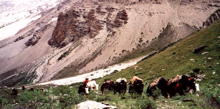
While waiting for lunch a gaily decorated yak is coming down from further up, leading a group of 30 big, hairy yaks that carry little bags. I wonder what makes those big, sturdy animals so fascinating, is it their archaic appearance, thick long fur and big horns, or because they seem so carefree and modest? Getting them to walk in the specified direction is no easy task and three tough looking men are busy throwing stones to guide the animals. Just three minutes later the spectacle is over and it is as quiet as before, making the short encounter seem unreal.
Life without yaks would be impossible in Upper Dolpo. “The yaks are our parents. We could not survive here without them. Like our children, each one has a different name.” They are yak thabo when they are black with white spots, yak dongbo when they have a white star on the forehead, yak kawa when they a white head, tsen yak when they are golden, yak ralden when their horns are not symmetrical. They are lha yaks when their fur is immaculate. These are scared and never killed for their meat. Their fur is never cut. They will never carry loads that are considered impure – boots or clothes. Every year, a ceremony is given to honour them. When they grow old, they are left in peace, and when they die, like the Dolpo people, their bodies are cut up and offered to the vultures. The yaks give their strength to carry loads for man. They provide milk, meat and leather. Their fur is used to make ropes, sacks, and the Drok-pa’s black tents. On the high plateau, “where there is not even a word to describe a tree”, yaks furnish the only source of fuel: dried dung. [Valli]
The little creek takes a left turn, grass grows on rock cliffs and further up is a glacier. The right side is not covered by any vegetation, it is a barren slope. After crossing the river it becomes clear: we will go up, up, up. First we climb through gravel, then up a grassy ridge, up another slope with small flowers and bushes, and finally across another gravel field. I walk slowly, trying to safe as much energy as I can for acclimatisation, for we will spend the night above 4’500 m.
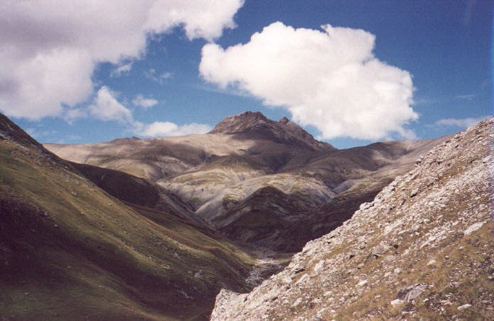
With every hill I climb my expectations for a great view grow, but all I get to see are just other, higher hills. After two hours I finally reach a point where the trail goes down again – at least temporarily. A high ridge forms the horizon, on its centre stands a huge block of red rock, to its side are red-brown coloured hills which resemble dunes. Small streams flow down from the top and cut the dunes into pieces, each of which has its own tone of colour. Somewhere up there is Kang La, our first pass over 5’000 m. We will set up a ‘base camp’ on one of the pastures below. This sounds easier than it is – finding a flat stone free area near the river proves quite difficult. Dawa and Khami who went ahead to look a suitable spot are rewarded by spotting blue mountain sheep. By the time we get there they are gone, but with a little luck we will see more tomorrow near Shey.
I don’t feel very tired but it is good to rest anyway. Closeby hills invite for further climbs, but after a day of walking I am not eager enough, although the idea of standing atop one of the high points is very tempting. Who knows how much energy I will need tomorrow?
|
Summary Part 2:
The three days in the narrow valley and dense forest were enjoyable, but I am ready for a change of scenery. After crossing a high ridge we are close to Ringmo. The stunning views are an unforgetable sight, the houses lie between green wheat fields and the turquoise lake. A rest day leaves us enough time to explore the village and its surroundings. Nepal's highest waterfall and the Bon monastery are easy to reach, further climbs will help us acclimatize. The way to Shey runs along the Phoksumdo river, we enjoy a last fantastic view of the village from a ridge high above the lake. Following a glacial valley brings us afoot our first high pass. We set up camp below the ridge after which the barren Tibetan landscape starts. Tomorrow we will cross the first pass above 5'000 metres and reach Shey gompa. |